


- Home >
- Science
- > Exploration
What’s a 100-year flood? A hydrologist explains
A 100-year flood refers to a flood event that has a 1% chance of occurring in any given year, not one that happens once every 100 years. This term helps communicate flood risk to communities, guiding infrastructure planning and insurance requirements. Hydrologists use historical data and statistical models to predict the likelihood of such events. However, climate change and urban development can alter these probabilities, making the concept more complex and dynamic over time.
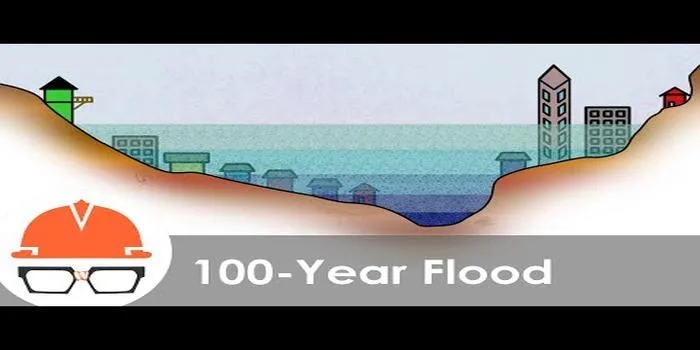
A 100-year flood is a term commonly used in hydrology and flood risk management to describe a flood event that has a 1% chance of occurring in any given year. This statistical concept can often lead to misunderstandings, as people may mistakenly believe that such a flood only happens once every 100 years. In reality, there's a 1 in 100 chance of it occurring in any given year, which means that multiple 100-year floods can occur within a single decade or even a few years.
Understanding the 100-Year Flood Concept
The ''100-year flood'' is a crucial metric used by urban planners, engineers, and environmental scientists to assess and manage flood risk. It is primarily derived from historical rainfall and streamflow data, which are analyzed to determine the probability of floods of varying magnitudes. The analysis considers factors such as rainfall intensity, soil saturation, and watershed characteristics.
To illustrate this concept, consider the following table that summarizes key aspects of the 100-year flood:
| Aspect | Description |
|---|---|
| Definition | A flood that has a 1% chance of being equaled or exceeded in any given year. |
| Frequency | Can occur more than once in a century, with a 1% chance each year. |
| Importance | Helps in designing infrastructure and managing land use to mitigate flood risks. |
Statistical Analysis and Flood Zones
Hydrologists use statistical methods to analyze historical flood data. They plot the data on a flood frequency curve, which helps in determining the magnitudes of various flood events. The ''100-year flood'' line on this curve represents the threshold for significant flood risk. This analysis is essential for zoning regulations, insurance rates, and municipal planning.
In the United States, the Federal Emergency Management Agency (FEMA) designates ''Flood Insurance Rate Maps (FIRMs)'' that outline areas at risk for 100-year floods. These maps classify regions into different flood zones based on their risk levels. Properties located in a 100-year floodplain may be required to carry flood insurance, reflecting the heightened risk of flooding.
Misconceptions about 100-Year Floods
One of the most common misconceptions about the ''100-year flood'' is that it signifies a flood of a specific size or magnitude. In reality, the term refers to the probability of a flood occurring, not its intensity. For instance, a 100-year flood in one region might be a different magnitude than a 100-year flood in another area due to variations in topography, land use, and climate. Therefore, it is essential to consider local conditions when evaluating flood risks.
Another misconception is that a 100-year flood will not occur again for another century. In fact, as climate change continues to influence weather patterns, the frequency and intensity of extreme weather events may change. This means that areas previously considered safe could become vulnerable to ''100-year floods'' or even more severe flooding events in the future.
Preparing for 100-Year Flood Events
Given the potential for ''100-year floods'' to occur more frequently due to climate change, it is crucial for communities to be prepared. Here are some strategies that can help mitigate the impact of such flood events:
- Infrastructure Improvements: Investing in resilient infrastructure, such as stormwater management systems, levees, and floodwalls, can significantly reduce flood risk.
- Zoning Regulations: Implementing strict zoning laws in flood-prone areas can prevent development that increases flood risk.
- Public Awareness: Educating residents about flood risks and emergency preparedness can save lives and minimize property damage.
The Role of Technology in Flood Prediction
Advancements in technology have significantly improved the ability to predict and model flood events. Tools such as Geographic Information Systems (GIS), remote sensing, and advanced hydrological models enable scientists to analyze data more accurately and provide timely warnings to communities at risk. The integration of ''real-time data'' from weather stations and river gauges further enhances forecasting accuracy, helping to mitigate the impact of ''100-year floods''.
Final Thoughts
Understanding what a ''100-year flood'' truly means is vital for effective flood risk management. By recognizing the statistical nature of this term, communities can better prepare for and respond to flooding events. With climate change influencing weather patterns and increasing the likelihood of extreme weather, it is more essential than ever to invest in infrastructure, adopt smart zoning practices, and leverage technology for improved flood prediction and response.
Ultimately, preparation and awareness are key to minimizing the impacts of ''100-year floods'' and protecting lives and property in vulnerable areas.